Bengaluru is spatially characterized by a ring-radial system of roads formed by five big axes, which converge towards the centre of the city. Bengaluru Metropolitan Area with more than 11 million people, travelling is getting more and more difficult as the city witnesses nearly 10 million trips a day. Traffic in Bangalore has become a scourge and is only becoming worse. Network speeds are dropping at an alarming rate as overcapacity of its junctions and links are being reached and traffic jams have become the order of the day. Being a victim of its own success, Bangalore’s traffic infrastructure has just not been able to keep pace with the fast growing IT industry to which Bangalore is associated with.
Today, home to more than 11 million people the strained network is loaded with more than 100 lakh trips per day. BMTC operates more than 6000 buses and carry more than half these trips, but this is hardly enough, the rest of the traffic has simply overwhelmed the network.
The paucity of public transport services, lack of road network, over dependence of private vehicles and a high growth rate with the city (in the past decade, the city has nearly doubled), has resulted in:
Traffic Jams/ Extreme congestion
Decline in journey speeds from 18kmph (2008) to 11kmph (2015) leading to severely overburdened Road Network and long commute times.
• Present trip rate 0.9 per capita per day – approximately 90 lakh trips per day
• Mode share 52% trips on vehicular traffic and 48% on Public Transport (includes private buses)
Absence of clearly defined road network hierarchy
• Network congestion hampers bus operations significantly - Share of Public Transport dropping further
Growing use of personalized vehicles
Intensification of existing economic nodes leading to traffic congestion
Deficient multimodal integration
Movement of Freight/ Goods inside the city area
Intercity Bus Travel Movements disorganized and is scattered all over the city
Non-Motorized Transport is inadequate with respect to provisions of footpaths and cycling facilities.
Parking is disorganized in most parts of the city.
A high car dependency has also added to high air and noise pollution levels
BANGALOE AUTHORITY ★
To address the growing concerns of the prevailing and anticipated traffic demands, it is imperative to understand the traffic related issues both at a macro level and a micro level. Hence, to respond to transport requirements of future more appropriately, for the first time in a master planning exercise in India, a transport model has been developed with a focus on integrating land use and transport planning. The model has more than 500 zones and includes 15000 road links and 2300 bus routes.
11.2Model Development for the Revision of Master Plan
A state of the art transportation modelling suite (CUBE VOYAGER) has been employed for the modelling purpose. A detailed circulation network was drawn taking into cognizance the spatial growth of the city and the road proposals of RSP 2031 and RMP 2015. On this circulation network BMTC bus routes where meticulously coded. All the wards in the BBMP zones and the Villages up to the BDA limit were considered as individual zones. The model was extended to include the BMR as many transport solutions may include the BMR region as well. The Origin and destination data was estimated from the earlier Comprehensive Traffic and Transport Study (CTTS) calibrated functions and further refined and brought up to date through a process called “Matrix estimation from Counts”.
A conventional four stage model was calibrated for Bangalore afresh, and validated across screen lines to prove that the input data is satisfactorily representing city travel. The model was calibrated over 4 modes, Cars and Taxis, Two Wheelers, Auto rickshaws and Public Transport. Trucks, Multi Axial Vehicle’s (MAV’s), Light Commercial Vehicle’s (LCV’s) and Bicycles where separately considered for the assignment. The model has been calibrated to represent the morning peak period – the journey to work period (the period used for network capacity analysis)
11.3Forecast Scenario
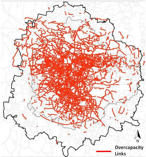
The model was run for 2031 assuming spatial growth in line with the growth trends observed today. The metro phase 1 and phase 2 were included in the model. The peripheral ring road was included. The existing network was also improved to a limited extent – example the outer ring road was fully completed and buses have been doubled. The forecast Business As Usual (BAU) scenario shows very high congestion, the followings are the key observations. Refer Figure 11-1.
• The Vehicular trips increase more than 3 times and the network is severely congested
Public Transport share reduces substantially
Bus frequency would reduce to less than half even with double the fleet
• Almost all roads will be operating at higher than Capacity
Network speed drops to 8kmph. In the peak direction its < 5kmph. A clearly non sustainable situation.
The pollution levels from vehicular emission would increase 3 times
• Doing nothing but believing that the Metro phase-II will solve Bengaluru’s problem is not a solution
AUTHORITY ★
Figure 11-1: Map showing Over-capacity links as per Business as Usual or Do Nothing scenario for BMA 2031
Source: RMP 2031 Analysis
11.4Approach to Traffic and Transport Planning of the BMA
Conceptually, the larger mobility strategy has been to move people through rings and radials of higher order mass transit systems and a well formed road network that exhibits a strong hierarchy of roads. The main intent has been towards integration of land use with the overall transport network to significantly enhance public transport use. The circulation network establishes strong grid patterns which represent the spatial organization of an orbital and radial form. Also integration of intermodal hubs are being proposed at locations where different mass transit corridors meet, independent of the selected system to help in efficient interchanging. The accessibility is not being addressed in detail within the ambit of the Master Plan study but the essential base network is being setup to ensure that good end mile connectivity to the mobility corridors are easily achievable.
A major mass transit station is within 3 to 4 kms of any part of Bangalore which can be fitted with an end mile connectivity solution.
• Cross sectional elements of the road networks are set with proper footpaths and segregated cycle tracks.
Minor bus terminals are being provided in all areas to ensure that a feeder system can be operated. These can be fitted with charging ports to facilitate Electric Vehicle’s (EV’s).
BANGALOE AUTHORITY ★
The Multi Utility Zones proposed in the larger road network have been conceived to include Intermediate Public Transport (IPT) stands or Taxi Stands which can be included adjacent to mass transit stations to enable efficient end mile connectivity.
Also, the Multi Utility Zones proposed as part of the road cross sections can also house Public Bicycle docking stations. Given that all major roads will compulsorily have a cycle track dedicated), it should be easy to put in place a Public Bicycle Sharing System to help improve end mile connectivity
11.5Transport Strategy
Considering the current challenges that Bangalore is facing and the Business as Usual forecasts which shows a totally unsustainable situation, a set of key priorities or principles are devised that underpin the development of the transport strategy. The strategy seeks to address the concerns of all segments of commuting population by emphasizing the pre-eminence of public transport and non-motorized modes of travel; adopting various elements of Travel Demand Management and integrating with the land use development scenarios. This is in line with the National Urban Transport Policy. The following measures have to be considered while implementing the master plan:
Improve the existing road network by developing a network structure and define the road hierarchy. Provide additional rings/radials wherever possible and consider urban road design as an important element.
Focus on providing more public transport targeting to carry 70% of trips of the city from the present 50%. Seriously consider more transport spends on provision of Metro/BRT/Monorails etc. Push for the Commuter rail system.
Establish a street network model design which intrinsically has provisions for pedestrians and cyclists. Consider that the Pedestrian is also a road user – provide comfortable/safe facilities for pedestrians. Re-establish the role of bicycles in Bangalore and encourage/provide for them.
To bring 20-25% of Planning Area under Transit Oriented Development
Provide a freight movement plan with logistic hubs and warehouses interconnected with dedicated freight corridors
Reorganize interstate bus and rail hubs and integrate the same with the local public transit systems for seamless intermodal transfers.
Other critical transport elements that need to be considered but is not explicitly spelt out in the master plan are as follows:
Traffic management is assumed to be efficiently handled through state of the art ITS. The BTRAC programme that is already part implemented in Bangalore should be continued to bring in the best technologies in the market to ensure that traffic management is at its efficient best.
It is assumed that BMTC buses have to be increased to 15,000 by 2031.
★
The shift to public transport can never be achieved if some form of demand management is applied. One of the best forms of demand management that is already in an advanced stage of thinking is parking charges. While this would push private mode users away from cars and two wheelers the city authorities can also be assured of a regular source of income.
Other demand management measures such as increasing restriction; corridor pricing etc must be pursued after the implementation of the Public Transport Network.
11.6Traffic and Transportation Proposals
11.6.1 Circulation Plan
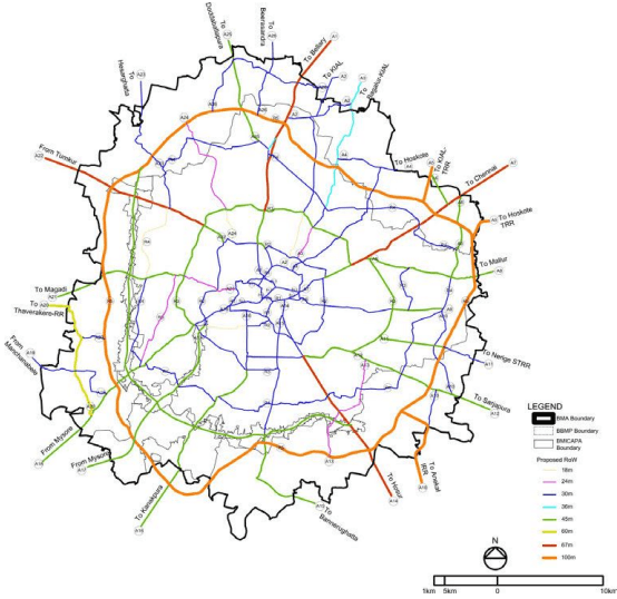
The circulation network has identified radial and ring roads to create more opportunities for mobility within the metropolitan area and the larger region. The proposed circulation network will have about 800 Kms (including existing 375 kms) of Primary Arterial which has 26 radials and 5 rings. The primary circulation network embraces completely new ring road (Inner Peripheral Ring Road) apart from the completion of the Intermediate Ring Road and the Peripheral Ring Road. A detailed Primary Circulation Network Plan along with an inventory is shown in Figure 11-2 and a summary of the inventory is given in Table 11-1.
Table 11-1Inventory of Existing and Proposed Primary Circulation Network (Category-1 Projects)
Sl. No.
Road Code
Road Name
Road Type
Approximate Length (kms)
Alignment Status
Existing
Proposed
1
R1
Inner Ring Road
Arterial
40
2
R2
Intermediate Ring Road
Arterial
40
3
R3
Outer Ring Road
Major Arterial
60
R3
Old Outer Ring Road
Arterial
9
R3
Hoodi/ Graphite India Main Road
Arterial
5
4
R4
Inner Peripheral Ring Road
Arterial
105
5
R5
Peripheral Ring Road
Major Arterial
118
R5
NICE Ring Road
Major Arterial
44
6
A1
Bellary Road (AH43)
Major Arterial
20
7
A2
Nagawara Main Road
Major Arterial
26
8
A3
Hennur Main Road
Major Arterial
16
9
A4
Banaswadi Main Road
Major Arterial
12
10
A5
Hoskote TRR Road
Major Arterial
6
11
A6
SH 35/ Sivas Road
Major Arterial
7
12
A7
Old Madras Road (NH4)
Major Arterial
18
13
A8
Whitefield Main Road
Major Arterial
11
14
A9
Old Airport Road
Arterial
14
AUTHORITY ★
Sl. No.
Road Code
Road Name
Road Type
Approximate Length (kms)
Alignment Status
Existing
Proposed
15
A10
SH 35/ Chandapura-Domasandra Main Road/ Anekal IRR Road
Major Arterial
13
16
A11
Kadabessanahalli Main Road
Arterial
9
17
A12
Sarjapur Main Road
Major Arterial
13
18
A13
Haralur Main Road
Arterial
11
19
A14
Hosur Main Road (AH45)
Major Arterial
18
20
A15
Bannerughatta Main Road (SH87)
Major Arterial
20
21
A16
Kanakpura Main Road (NH 209)
Major Arterial
18
22
A17
Mysore Express Way
Arterial
17
23
A18
Mysore Main Road (SH17)
Major Arterial
19
24
A19
Dodda Almara Main Road
Arterial
9
25
A20
Thaverakere Ring Road
Arterial
18
26
A21
Magadi Main Road (SH85)
Major Arterial
14
27
A22
Tumkur Main Road (AH47)
Major Arterial
16
28
A23
Hessaraghatta Main Road (SH39)
Major Arterial
6
29
A24
Jallahalli West Main Road
Arterial
10
AUTHORITY ★
Sl. No.
Road Code
Road Name
Road Type
Approximate Length (kms)
Alignment Status
Existing
Proposed
30
A25
Dodda Ballapur Main Road (SH9)
Major Arterial
12
31
A26
Sir MVIT College Road/ Beerasandra Road
Arterial
21
Total
795
Some of the important new alignments identified are:
Completing missing links within the Intermediate Ring Road which include connecting CIL Main Road and Pottery Main Road, connecting Byapanahalli Main Road and Pottery Main Road and augmentation of Banashankari 50 feet road which connects to BMIC Expressway
Inner Peripheral Ring Road, which is a newly identified ring in between ORR and PRR. The alignment is a combination of existing and new roads. It connects suburbs such as Yelahanka, Jakkur, RK Hegde Nagar, Horamavu, Kithaganur, Sonnenahalli, Kadugodi, Varthur, Chikka Begur, Hulimavu, Kengeri, Ullal, Nagasandra and Chikbanavara. This is a critical link as it constitutes areas which will further densify in the coming years.
As mentioned earlier the PRR is critical to BMA, the master plan also proposes that the PRR connects to NICE corridor at Tumkur road portion.
Two new links are proposed to BIAL other than the existing Bellary Road and Hennur Road. One is an extension of existing Nagawara Main Road and the other is extension of SH-35 at Old Madras Road via Sivas Road.
Extension of Banaswadi Main Road via Panathur Main Road towards Hoskote LPA
Developing a 30m road between Dodda Ballapur Main Road and Bellary Road towards Beerasandra (SH 104) in BIAPPA LPA
• Integration of Regional connections with STRR at Nelamangala, Hoskote and Anekal LPA’s respectively.
11.6.2 Public Transport Systems
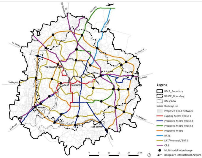
As discussed a complex grid of radial and ring systems have been proposed complimenting the metro phase 1 and 2. The mass rapid transit systems proposed is as per the Table 11-2 and as shown in Figure 11-3. The selection of mass transit system is based on the section load (passenger per hour per direction) for selected systems.
AUTHORITY ★
Table 11-2Existing and Proposed Public Transport Systems under RMP 2031
Sl.No
Corridor
Length (kms)
System
1.
Metro Phase 1
42.4
Metro (Implemented)
2.
Metro Phase 2
81.4
Metro (Under Implementation)
3.
Metro Phase 3 (Airport Link)
29.5
Metro (18.3 km within BMA)
4.
Commuter Rail Network
106
Commuter Rail System
5.
Intermediate Ring Road (R2)
37
LRT/ Monorail/ BRTS (Medium Level)
6.
Outer Ring Road (R3)
62.6
Metro
7.
Inner Peripheral Ring Road (R4)
81.8
LRT/ Monorail/ BRTS (Medium Level)
8.
Peripheral Ring Road (R5)
106
Metro
9.
Bellary Road (A1)
13.5
LRT/ Monorail/ BRTS (Medium Level)
10.
Hennur -Bagalur Main Road (A3)
21.6
BRTS
11.
Sarjapura Road (A10)
26.3
LRT/ Monorail/ BRTS (Medium Level)
12.
Old Airport Road (A8)
26
LRT/ Monorail/ BRTS (Medium Level)
13.
Magadi Road (A20)
9.2
LRT/ Monorail/ BRTS (Medium Level)
14.
Jalahalli West Main Road (A24)
10.4
LRT/ Monorail/ BRTS (Medium Level)
Total
653.7
11.6.3 Bus Augmentation
BMTC, at present is operating 6249 buses on 2500 routes. There are 10 TTMC’s (Traffic and Transit Management Centre’s) and 40 depots, new depots and TTMC/ Bus Terminals have been identified within the newly planned areas of BMA. It is assumed that the bus fleet size will be in the range of 15,000.
11.6.4 Interstate Bus Terminal
BMTC along with KSRTC provides the regional/ interstate connectivity from Bangalore to other parts of the cities and vice versa. A total of six interstate bus terminals are proposed on Tumkur Road, Mysore Road, Old Madras Road, Hosur Road, Bellary Road and Magadi Road so that intercity traffic will not get mixed with the city traffic.
BANGALOE AUTHORITY ★
11.6.5 Intermodal Interchange
RMP 2031 has proposed 36 intermodal interchange stations intersections of two or more public transit corridors.
11.6.6 Freight/ Goods Infrastructure
In order to restrict the freight movement inside the city, eight logistic hubs of 100 acres each is proposed at the periphery of major highways. Logistic Hubs are proposed on Bannerughatta Road, Tumkuru Road (outside BMA), Mysore Road, Mallur Road, Bellary Road, Old Madras Road, Hosur Road and Sarjapura Road.
Figure 11-3: Map showing Proposed Public Transport Network of RMP 2031