5.1 Relevance of GIS in Master Planning
Spatial data plays a key role in better decision making, planning and management of cities. In order to have sustainable planning and management it is important for planners, administrators and city managers to have access to reliable, seamless and reasonably accurate data. Satellite imagery and Geographical Information Systems (GISs) are tools that facilitate developing datasets for preparation of rapid, comprehensive, rational and implementable plans. In other words, a robust Geospatial database becomes a useful basis for making rational planning decisions for sustainable planning, development and management.
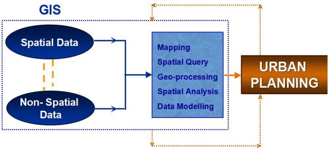
Geographical Information System (GIS) is essentially a comprehensive spatial and decision support system of computer hardware or software tools to merge spatial, preferably geo-referenced data with the non-spatial data for deriving meaningful information to be used for urban planning. The distinguishing factor that separates GIS from the other information storage and retrieval systems is the use of locational features in a co-ordinate space as the fundamental referencing principle and as important variables in quantitative analysis.
Mapping provides the most powerful visualization tool in GIS. GIS is used for preparation of land use & circulation maps, thematic maps related to socio-economic data, environmental data, infrastructure services data, revenue data and can be used for wide ranging planning applications. Planners and City Managers extract useful information from this database, containing spatial and non-spatial data.
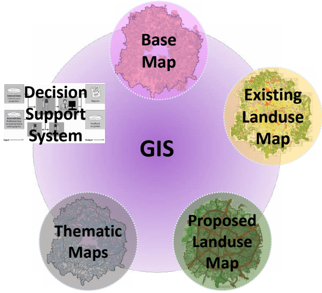
Figure 5-1: Inter-relationship between GIS and Urban Planning
AUTHORITY ★
5.2 Application of GIS in RMP-2031
GIS based planning information system has been used for the preparation of RMP-2031 for the following aspects:
a) Base Map
b) Existing Land Use
c) Proposed Land Use, Circulation Plans, Sectoral Plans etc.
d) Thematic Maps for analysis and use.
e) Development of a GIS to support Planning Decisions
Figure 5-2: Evolution and Usefulness of a GIS for Urban Planning
★
5.3 Methodology for Base Map and ELU
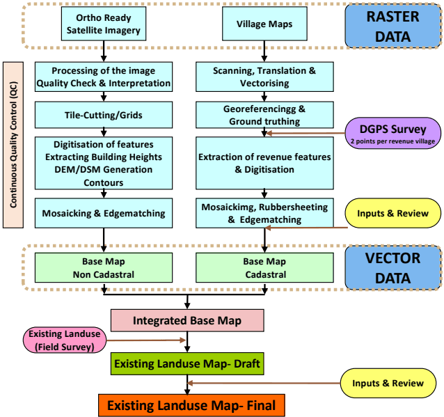
The Base Map & Existing Land Use (ELU) Map has been prepared using High Resolution Satellite Imagery, superimposed with Cadastral information supported by extensive field surveys for the entire Bangalore Metropolitan Area (BMA) comprising of LPA of BDA and LPA of BMICAPA (in part) spread across an area of 1294 Sqkm. The base map is the foundation for developing a proper existing land use map which in turn is critical for formulating alternatives, scenarios and proposals in a Master Planning exercise. The Existing Land Use plan shows various current land uses at the specified, reasonable scale and detail indicating residential, commercial, industrial, public & semi-public uses, recreational (parks & playgrounds), open spaces, vacant land, land under agriculture, water bodies, utilities & services facilities, circulation system, conservation areas, special areas, committed land uses, etc. In addition, along with Base Map and Existing Land Use, DEM/ DSM, contours and building heights have also been captured and various thematic maps have been generated. Figure 5-3 presents the overall methodology chart describing the process adopted for preparation of Base Map & then ELU Map for RMP 2031.
Figure 5-3: Overall Methodology for Preparation of Base Map & Existing Land Use Map
BANGALOE AUTHORITY ★
5.4 Base Map Preparation
The most crucial information for preparing any master/ spatial plan is an accurate and updated base map of the planning area. It is a necessary component, without which no spatial planning exercise can be undertaken. A base map helps the planners and administrators to prepare the existing land use, circulation pattern, road networks, spatial extent of development, natural features, and also information on the use of each land parcel including man-made and natural features on ground. It brings together in a common base the physical features, topography, drainage pattern, water bodies, power lines, road network, rail, forest area, settlement areas etc.
The Base Map for RMP 2031 has been generated by extracting spatial features visible from high resolution satellite imagery and integrating with other sources of information such as revenue/cadastral maps and relevant spatial information available including maps sourced from various other government departments. Appropriate techniques were deployed to improve the accuracy of the information and also the geo-referencing.
5.4.1 Process & Methodology
The base map preparation for RMP 2031 involved three broad stages:
a) Preparation of Base map- Non Cadastral (with the use of Satellite Imagery)
b) Preparation of Base map- Cadastral (with Revenue Village Maps)
c) Preparation of Integrated Base map (Superimposing of base map obtained from satellite imagery and cadastral maps)
A. Preparation of Base map- Non Cadastral (with the use of Satellite Imagery)
The Base Map for RMP 2031 contains features extracted from the satellite images like buildings, roads, natural features (lakes & streams/ drains), contours, railway line, metro rail line, power substation, High Tension Power lines, Sewage Treatment Plants etc. Secondary spatial data of other departments has also been integrated with the base map to form the overall geospatial database. Satellite imagery (GEOEYE -1, with 0.5 Meters and 2 Meters resolution for PAN and MSI respectively) was used for this purpose. Part of the BMA area which was under cloud cover in the original satellite imagery was updated using fresh satellite imagery (Archive Data, World View 01 -0.5 mtrs and PAN & Multi Spectral Ortho Image, 2015). Appropriate steps were taken to properly merge the two satellite images to extract relevant features and complete the base map.
B. Preparation of Base map- Cadastral (with Revenue Village Maps)
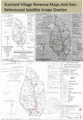
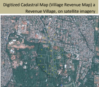
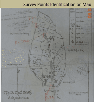
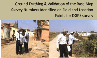
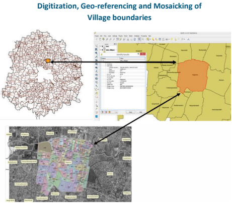
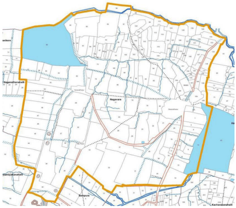
The Cadastral Maps (revenue maps) were procured (in Paper as well as jpeg/ pdf files in soft format) from the Revenue Department, GoK scanned, digitized, mosaicked, geo referenced and integrated in to the geo-spatial data. All the revenue survey numbers were translated to English. Ground truthing and validation of Base Map has been carried out through preliminary field identification (x,y coordinates) of survey points on the village maps followed by point data collection using Differential Global Positioning System (DGPS) equipment and capturing two points per revenue village. The
5.5 Existing Land Use Map
The Existing Land Use (ELU) is the next critical input in devising the future growth strategy of any city/town, formulating alternatives and proposals in any Master Planning exercise. The ELU maps show various current land uses at the specified and reasonable scale indicating residential, commercial, industrial, public & semi- public uses, recreational (parks & playgrounds), open spaces, vacant land, land under agriculture, water bodies, utilities & services facilities, circulation system, conservation areas, special areas, committed land uses, reservations and mixed land uses etc.
BANGALOE AUTHORITY ★
Urban land activities/ uses are numerous like residential, mixed residential, commercial, mixed commercial industrial, mixed industrial or recreational and with various combinations. Activities with similar nature have been clubbed together and Land Use classification prescribed under KTCP Act and Rule 30 of the Karnataka Planning Authority Rules have been followed for land use codification, for capturing the data on ground and preparation of Existing Land Use Map 2015. The ELU maps are based on field surveys that have been carried upto Dec 2015. To collect information and map the existing land use of the BMA a comprehensive approach and methodology was taken, wherein satellite imagery interpretation and an extensive existing land use field survey across BMA formed the basis for mapping and ELU map preparation. Since the city is a dynamically growing entity it is difficult to capture the exact land use in detail. The existing land use survey exercise is primarily aimed at capturing the overall land use pattern, general growth trends and other ground conditions. This is to assists in the preparation of the overall master plan.
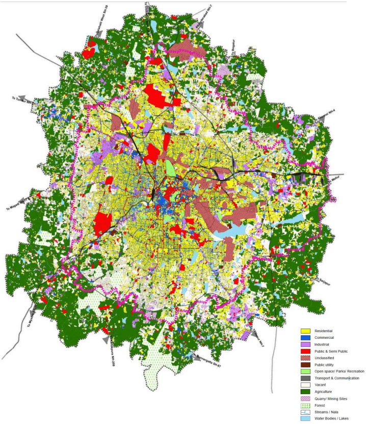
The ELU maps were finalized after due scrutiny. After completing the existing land use mapping exercise the overall land use pattern has been studied. The ELU maps have been printed out at 1: 5000 in a standardized format and have been utilized for preparing the proposals. Overall composite ELU Map is presented in Figure 5-6, whereas the ELU Area Statement for LPA of BDA is given in Table 5-1.
| Land Use Category | Area (Sq.km) | Share (%) |
|---|---|---|
| Residential | 212.84 | 17.63% |
| Commercial | 38.28 | 3.17% |
| Industrial | 45.61 | 3.78% |
| Public Semi Public | 64.78 | 5.37% |
| Unclassified | 42.32 | 3.51% |
| Public Utility | 4.86 | 0.40% |
| Parks & Open Spaces |