10.1 Considerations for Extension of Conurbation Limits
The Differential Strategy Scenario was approved by the Bangalore Development Authority for detailing of the RMP-2031 in a Board meeting held on June 9, 2017. Summary of the directions/ decisions by the Authority are given hereunder:
While delineating the additional land requirements for the extension of conurbation limits of RMP 2015 for RMP 2031, the aspects related to circulation pattern, buffer zones, affordable housing and economic nodes should be considered as per the outcomes of the public consultation meetings.
The indicative identified economic nodes should be located near to the junctions of the major roads to the extent possible and the activities should be suitable for such locations and balance with the regional context. The proposals of the Master Plans of adjacent LPAs should be considered while formulating the proposals for RMP 2031 to achieve the balanced regional development. Separate regulations should be considered for these nodes.
Based on the decision and guidelines given by the Authority, the conurbation limits have been extended with the following considerations:
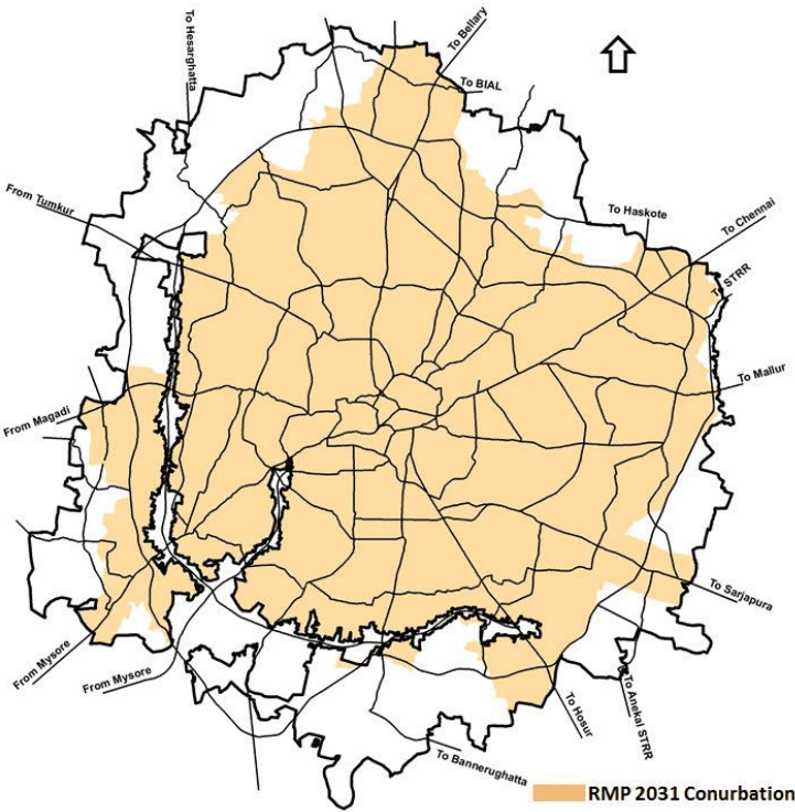
The Major road corridors considered for extension of conurbation considering the existing directions of growth and the capacity of the major road network, the five Special Development Zones (SDZ)/ Economic Nodes proposed are (1) SDZ Bellary Road, (2) SDZ Old Madras Road, (3) SDZ Sarjapur Road, (4) SDZ Hosur Road and (5) SDZ Mysuru Road.
The emergence of economic activities is highly governed as per the backward-forward linkage, however, it is a very dynamic phenomenon guided by the market demand. Considering the existing pattern of growth in these zones and in the adjoining region, SDZ Bellary Road, Hosur Road and Sarjapur Road would act as hubs of IT and other related Hi-Tech industries and supporting service sector Offices. SDZ Mysore road is envisaged as a hub for Knowledge Driven Economy. SDZ Old Madras road is envisioned to create opportunities through light and service sector industries.
The delineation of Special Development Zones as an extension of the conurbation limits of RMP 2015 has also taken cognisance of the existing level of development in these zones in order to plan for compact high density developments as per the availability of vacant land.
The Special Development Zones have been envisaged as High Density Integrated Developments providing employment opportunities (Economic Nodes) supported with the necessary residential and amenity requirements. The road network in these special development zones have accordingly been proposed to accommodate the high density developments.
BANGALOE AUTHORITY ★
The outgrowths of the conurbation limits of RMP-2015 where the intensity of development has been observed high with regard to the economic opportunities especially along the proposed PRR alignment.
Figure 10-1 depicts the proposed conurbation limit for RMP 2031.
Figure 10-1: Proposed Conurbation Limit for RMP 2031
10.2 Land Use Strategy for RMP 2031
The Land Use for RMP-2031has been proposed with the following considerations:
• The Land Use Zoning is as per the provisions of the Rule Number 30 of the KPA Rules.
For the purpose of detaining of RMP-2031, the entire LPA of BDA has been divided into 42 Planning Districts for which the Planning District Level Proposed Land Use Maps and proposed major development proposals are given in Volume-5 and Volume-4 respectively.
The commercial strip model including commercial axis, mutation corridor in the RMP 2031 has been relooked at and a multi-pronged strategy of planned commercial areas in the new areas of development and strip model on selected corridors/ roads of width 15 m and above has been provided based on the existing commercialisation in the existing developed areas.
The economic centres/ industrial areas and the amenity areas have been spatial distributed across different Planning Districts for balancing the growth at the LPA Level.
The Development Constraints such as Air Funnel Zones, regulations related to eco-sensitive zones, quarry and mining sites, defense areas etc have been given due cognisance while delineating the conurbation limits as well as formulating the land use proposals.
Except for the developments proposed along the five major corridors and the existing conurbation limits of RMP 2015, the agricultural belt admeasuring nearly 323 Sqkm has been retained along the periphery of the entre LPA to act as a buffer between the LPA of BDA and the developments in the adjoining LPAs.
The Proposed Land Use for RMP 2031 has considered and incorporated the planning permissions and change of land use accorded by the Authority/ Government. The Proposed Land Use of RMP 2015 has been suitably amended in several zones based on the predominant existing land use and the development pattern.
The entire LPA has been divided into three planning zone i.e.
Planning Zone A (Ring 1+Ring 2 of the RMP 2015) comprises of the core of the City area falling within the outer ring road (erstwhile BMP). Owing to limited availability of land and high densities, there is very little scope for further growth in this zone. This is also the zone that – owing to its high densities – is crippled by traffic congestion and environmental pollution. This zone requires, strategies to stabilise the growth in this zone and interventions that discourage further commercialisation in the residential areas as well as densification process.
Planning Zone B (Part of Ring 3 of the RMP 2015), the areas between the outer ring road and the proposed Conurbation limit of RMP-2031 form part of this zone. The infrastructure is poor in several areas in this zone, in spite of being major part falling under the jurisdiction of BBMP. Numerous lakes and water bodies present an opportunity to conserving the overall valley and tank network in the BMA. This zone is characterised by narrow roads and absence of a good network hierarchy. Improvement of infrastructure will lead to increased capacity to hold higher densities and more population in Zone B. The zone envisaged as zone of
10.3 Proposed Land Use 2031
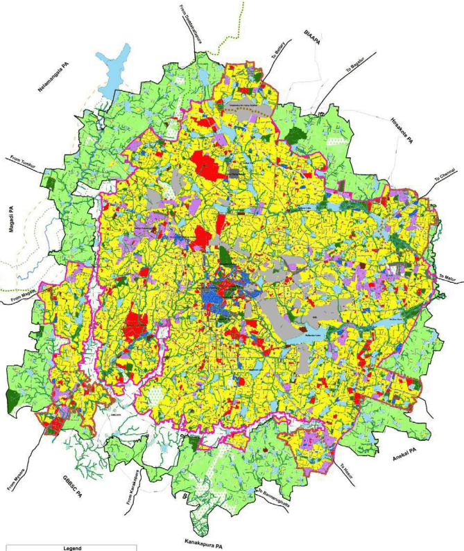
The Figure 10-2 presents the proposed land use plan for RMP-2031 for the entire LPA of BDA, whereas .proposed land use break-up for conurbation limit of RMP 2031 is given in Table 10-1.
| Landuse Category | Area (Ha) | % To Total Developable Area |
|---|---|---|
| Residential | 42477.08 | 48.03 |
| Commercial | 2473.74 | 2.80 |
| Industrial | 4256.47 | 4.81 |
| Public & Semi Public | 6007.85 | 6.79 |
| Public & Semi Public - Defence | 4356.28 | 4.93 |
| Public Utility | 471.15 | 0.53 |
| Parks / open spaces | 3734.55 | 4.22 |
| Transport & Communication | 11834.34 | 13.38 |
| Forest | 577.15 | 0.65 |
| Water Bodies and Streams | 3393.56 | 3.84 |
| NGT Buffer | 8848.90 | 10.01 |
| Total Developable Area | 88431.06 | 100.00 |
| Agriculture Zone | 32266.00 | - |
| Total Conurbation Area | 120697.00 | - |
AUTHORITY ★
Figure 10-2: Proposed Land Use for RMP 2031 (draft)
AUTHORITY ★