2.1 Introduction
Karnataka, a vibrant, unique, multi-cultural, multi-religious state, is the seventh largest state in India by area and eight largest by population size in India (Census 2011, came into existence in the Year 1956 and was called as State of Mysore and was renamed as Karnataka in the year 1973. Karnataka is located between 11˚ 34’ 59” and 18˚ 27’ 20” Latitude North and 74˚5’ 16” and 78˚ 35’ 17” Longitude East in the south western region of India and is bordered by the Arabian Sea and the Laccadive Sea to the west, Goa to the north west, Maharashtra to the north, Telangana to the North east, Andhra Pradesh to the east, Tamil Nadu to the south east, and Kerala to the south west.
Figure 2-1 presents the location of Karnataka in the World and India and Bangalore Metropolitan Region in Karnataka. The total geographical area1of the state is 191,791 Sq. Km accounting for 5.83% of the total geographical area of the country.
Figure 2-1: Location of Karnataka, BMR & BMA
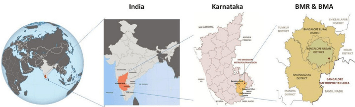
Note: Above figure is a graphical representation only.
The State is situated on a table land where the Western and Eastern Ghats converge into the Nilgiri Hills complex in the Deccan Plateau region of India. Karnataka has one of the highest average elevations at 1,500 feet.
Bengaluru is the largest city in Karnataka and the 5th most populous city in India. Bengaluru, is expected to become a Meta City with forward/ backward regional linkages (at Global, National, State and Metropolitan Region) which will have an impact on the growth of the city and it is thus important to understand the regional context while planning for Bengaluru. The City took shape as a fortified settlement under the ruler Kempegowda of the Vijaynagara state when he established the mud fort in year 1537.
1Source: www.karnataka.gov.in
2.2 Administrative Jurisdictions in BMR
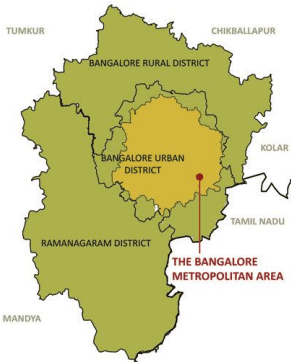
Bangalore Metropolitan Region Development Authority (BMRDA) is the regional development authority that has jurisdiction over BMR, and is functioning as per the provisions of Bangalore Metropolitan Region Development Authority Act (BMRDA), 1985. Bengaluru Metropolitan Region (BMR) is defined2as the combined geographical extents of three districts, namely Bengaluru Urban District (BUD), Bengaluru Rural District (BUR) and Ramanagara of Bangalore Revenue Division of the Karnataka State. Total extent of BMR is 8005 sq km.
Table 2-1 presents the details of districts (Name, geographical extent, name of taluks) within BMR.
| Sl. No. | Name of District | Area as per DRSP 2031(sq km) | Percentage Share (%) | Name of Taluks in District |
|---|---|---|---|---|
| 1 | Bangalore Urban | 2190 | 27.36 | North, South, East, & Anekal |
| 2 | Bangalore Rural | 2260 | 28.23 | Nelamangala, Dod Ballapur, Devanahalli & Hosakote |
| 3 | Ramanagara | 3555 | 44.41 | Magadi, Ramanagara, Channapatna & Kanakapura |
| 4 | BMR (3 Districts) | 8005 | 100% | Twelve Taluks |
Source: Revised Structure Plan for BMR 2031 by BMRDA, Administrative Atlas of Karnataka 2011, Census of India, 2011
Bangalore Development Authority, constituted under Bangalore Development Authority Act (BDA), 1976, exercises its planning and development function over its local planning area under the provisions of BDA Act, 1976 and Karnataka Town and Country Planning (KTCP) Act, 1961.
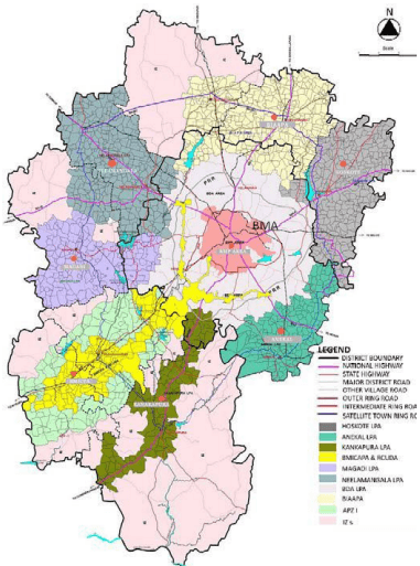
In addition to the Bangalore Development Authority, the other Planning Authorities within the jurisdictions of BMRDA include Hoskote, Anekal, Kanakapura, Magadi, BIAAPA, Neelmangala, Ramanagara-Channapatna and two recently added Planning Authorities namely Satellite Town Ring
2As defined by sub-section c of section 2 “Definitions” of Bangalore Metropolitan Region Development Authority Act, 1985.
AUTHORITY ★
Road Planning Authority and Greater Bangalore-Bidadi Smart City Planning Authority. The part of Bangalore Mysore Infrastructure Corridor Area Planning Authority (BMICAPA) created in the year 2001 also falls within the BMR. Figure 2-2 presents the present extent of various LPAs of Planning & Urban Development Authorities within BMR.
2.3 Urbanisation in the BMR
The share of Karnataka’s urban population to India’s urban population is 6.27% which has broadly shown a constant trend during past 6 decades. However, within urban Karnataka, the share of Bangalore Urban agglomeration (BUA) has more than doubled, increasing from 17.66% to 35.96%, during the period 1951 to 2011. Major share of Karnataka’s urban population resides in Bengaluru (38.31% of urban population), resulting in Bengaluru centric urbanisation in the state.
The population shows an increasing trend in BMR,
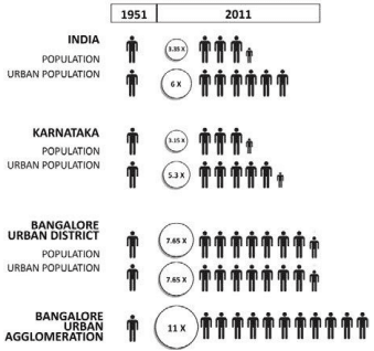
BUD, BMA primarily because of Bangalore City’s stupendous population growth. Bangalore Urban Agglomeration (BUA) has increased in population by ~11 times since 1951, growing at the rate of 4.05% CAGR since 1951. This rise is reflected in the population growth for BUD and BMR. The population of Class 1 cities (25 in number) of Karnataka together accounts for 58.17% (13.74million out of 23.63 million) of Karnataka Urban Population. The next city in the urban hierarchy after Bengaluru in Karnataka is Hubballi-Dharwad, with population of 0.9 million which is the size of Bengaluru. Out of 13.74 million population, Bengaluru alone has 8.5 million population, while balanced is distributed in 24 cities as per Census 2011.
2.4 Urban Growth Directions in the BMR
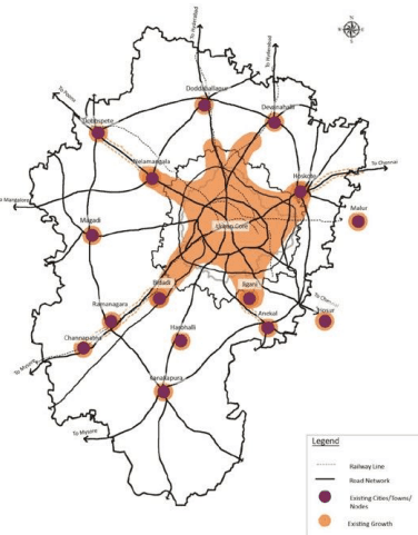
The Growth pattern in the BMR is characterised by Bengaluru City as the urban core (which has already engulfed Yelahanaka, Kengeri, Jigani, Yeswanthpur which were once satellite towns) and small urban nodes all around as satellites developed on radial road network in the region - like Anekal on Hosur Road, Hoskote on Old Madras Road, Devenahlli on Bellary Road, Neelmangala & Dobaspete on Tumukuru Road, Bidadi & Ramanagara on Mysuru Road, Kanakapura on Kanakpura Road. At present the ribbon development is seen on all major radial road and prominent ones being Tumukuru Road, Bellary Road, Old Madras Road, Mysuru Road and Hosur Road. The influence of urbanisation is beyond BMA and Karnataka state border and is evident from the fact that Mallur (in Kolar District) and Hosur in Tamil Nadu are growing because of Bengaluru. Figure 2-3 presents the urban growth pattern within BMR.
Figure 2-3: Urban Growth Pattern in BMR
BANGALOE AUTHORITY ★
2.5 Economy of BMA in the regional context
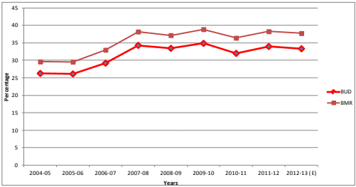
The largest share in Karnataka’s GSDP comes from Bangalore Urban District. In the year 2012-13, Bangalore Urban District alone contributed 1.81% to India’s GDP and 33.30% to Karnataka GSDP. As seen from Error! Reference source not found., the contribution of Bangalore Urban District to the GSDP of Karnataka has increased from 26.24% (2004-05) to 33.30% (2012-13). The Bangalore Metropolitan Region, during the same period (2004-2013), due to Bangalore Urban district, has steadily increased its share.
Figure 2-4: GDDP Share of BUD & BMR to Karnataka GSDP
Source: Economic Survey for 2004 to 2013, Directorate of Planning & Statistics, GoK
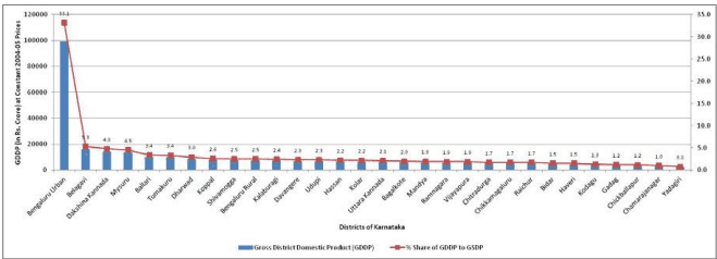
Figure 2-5 presents the District wise Gross District Domestic Product (GDDP) contribution to Gross State Domestic Product (GSDP) for the year 2012-13. The Gross district domestic product of Bangalore Urban has been, on higher side for most of years during 2004 to 2013. It is important to note here that the GDDP share of Bangalore Urban District is so large that it takes combined GDDP of 10 districts in hierarchy to equal the GDDP of Bangalore Urban District.
Figure 2-5: District wise GDDP & Its share to State GSDP (2012-13)
Source: Economic Survey for 2013, Directorate of Planning & Statistics, Government of Karnataka.
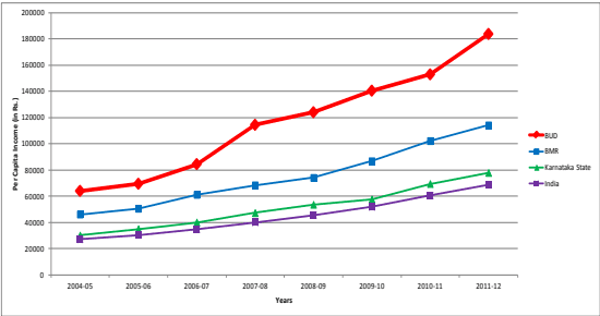
The annual per capita income at National, State, BMR and BUD (in 2011-12) is INR 68857, INR 77834, INR 114062 and INR 183607 respectively. The per capita income of BUD has always been higher than national, state and BMR level and so is the income growth rate. Since 2003-04 till 2011-12, the CAGR of per capita income has been 14.09%, 11.97%, 12.59% and 12.40% for BUD, BMR, State and National Level respectively. Figure 2-6 presents the per capita income for National, State, BMR and BUD Level.
Figure 2-6: Per capita Income Growth in BUD, BMR, Karnataka and India
Source: Economic Survey of India, 2004-14, Ministry of Finance, GoI; Economic Survey of Karnataka, 2004-14 Directorate of Economics & Statistics, GoK.
2.6 Industrial Infrastructure: Industrial Estates and SEZs
KIADB is the nodal agency for acquiring, developing and allotting industrial plots in the state. As on 2013, KIADB has developed 145 industrial estates in the state. There are 34 KIADB developed industrial estates in BMR out of which 16 (47%) are in BUD. KIADB has made an effort to develop industrial estates in a balanced way in the state, unlike the population distribution or other economic development in the state, which is mostly focused on BUD and BMR. All the developed plots in industrial estates have already been allotted showing that there is high demand for industrial land in and around Bangalore (in BUD and BMR).
Table 2-2 gives the number and extent of the KIADB areas in Karnataka, BMR and BUD.
There are currently 15 Operational SEZs with 172 units in BMA, with an employment of 177520, accounting for 91% of State’s share of SEZ employment. BMA also contributes 93% (Rs. 47791.7 Crores) of State’s SEZ exports.
BANGALOE AUTHORITY ★
| Name of the District | No. of Industrial Areas | Extent (Ha) | Allotted | ||
| Acquired | Developed | No. of units | Extent (Ha) | ||
| KARNATAKA | 145 | 17379.2 | 13299.1 | 16748 | 11351.2 |
| BMR | 34 | 6445.5 | 5017.8 | 4968 | 4181.2 |
| BUD | 16 | 2711.8 | 2230.0 | 3069 | 2228.9 |
| BUD to BMR % Share | 47 | 17.0 | 17.8 | 62 | 21.4 |
| BUD to KAR % Share | 11 | 6.5 | 6.9 | 18 | 8.1 |
| BMR to KAR % Share | 23 | 15.0 | 15.4 | 30 | 15.0 |
Source: KIADB Website (Status as on 31.05.2013)
2.7 Environmental Features in the Region
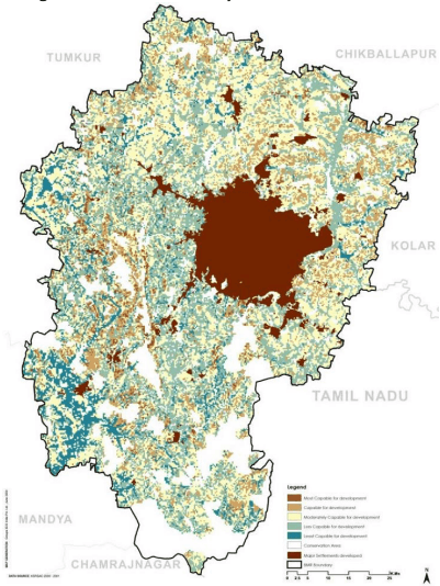
Protected and reserved forests (including National Parks) and Thippgondanahalli Reservoir – Arkavati river system are eco-sensitive zones within BMR. Lakes and valley systems within BMR are equally environmentally important resources. Figure 2-7 presents the map showing, forest areas, Thippagondanahalli reservoir sensitive area and the lakes within BMR.
Karnataka accounts for about six per cent of the country’s surface water resources3.There are seven river basins. The area under BMR & BUD is covered by three river basins namely - North Pennar, South Pennar and Palar, however the water supply requirements for Bangalore are met from Cauvery water.
AUTHORITY ★
Figure 2-7: Environmentally Sensitive Zones in BMR
Source: RSP- 2031. BMRDA
2.8 Regional Transportation Network
The Bengaluru metropolitan Region has well established air, road, railway connectivity, with Kempegowda International Airport (KIA) providing the air connectivity to the region. The Kempegowda International Airport (KIA) – the third busiest airport in India, located at Devanahalli, Bengaluru Rural District, is 45km away from city of Bengaluru and provides air connectivity to Overseas, National, and destinations within Karnataka.
Bengaluru City, the core of BMR, is well connected through NH4 (Mumbai – Chennai via Poona, Hubli, Tumkur, Bengaluru, Kolar), NH-7 (Banaras – Kanyakumari via Nagpur, Hyderabad, Bengaluru, Hosur, Madurai), NH 48 (Bengaluru- Mangaluru via Hussan), NH 275 Bengaluru – Mysuru and NH209 (Dindegul-Coimbatore-Bengaluru). In addition to NHs, the SH-85 (Magadi Road), SH-87 (Banerghatta Road), SH-37 (Whitefield Road), SH-9 (Dodaballapur Road), SH 35 (Whitefield to Sarjapur) and SH-104 (Thanisandra Main Road) have also strengthened the regional connectivity and integrated the satellite towns in the region with Bengaluru.
KIA statistics provided BIAL, 2015.
BANGALOE AUTHORITY ★
The Bengaluru division of SWR covers entire Bengaluru Metropolitan Region. Major stations within Bangalore Metropolitan Area are Bengaluru City Station Jn, Yeshwantpura Jn, Yelahanka Jn, Baiyyanpannahalli Jn. These stations are supported by second order stations like Bengaluru Cantt., Krishnarajapurama Station, Nayandahalli, Kengeri, etc. Railway network from Bangalore is extensively connected to inter-state and intra-state. It connects to Chennai (through Jolarpettai route) in the east, Chikkabellapur in the north east, Guntakal and Hyderabad (via Dharmaravam) towards the north, Tumkur in the northwest, Nelamangala in the west, Mumbai (via Goa), Mangalore & Mysore (via Ramanagara) in the south west and Coimbatore (via Salem) in the south.
Figure 2-8: Regional Transport Network of BMR
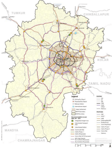
BMR RSP-2031 has proposed the regional connectivity plan to further strengthen the network within the region and minimising the through traffic crossing Bengaluru City. The major proposals of BMR RSP-2031 include STRR and ITRR that will help in easing the regional traffic in Bengaluru. The circulation network of RMP 2031 has integrated other proposals of the RSP 2031 for better regional connectivity.