3.1 Notifications for LPA of BDA
Government of Karnataka has issued several notifications amending the extent of LPA of BDA from time to time. These notifications have been collated with Revenue Maps, Census Maps and RMP 2015 base map showing administrative boundaries of villages in LPA of BDA. The Government Notifications defining the extent of LPA of BDA are:
-
Government Notification No. S.0.3446 dated 1st November 1965, declaring the Local Planning Area (LPA) for Bengaluru City was the first notification issued by GoK after enactment of Karnataka Town and Country Planning Act, 1961. This was much before the constitution of Bangalore Development Authority.
-
Government Notification No. HUD 496 TTP 83 dated 15th March 1984 and its “Schedule –I: Statement showing the list of Villages included in the Bangalore City Planning Area” declaring the Local Planning Area for the environs of Bengaluru. This notification is after the Constitution of Bangalore Development Authority under the provisions of Bangalore Development Authority Act, 1976. This notification further expanded the extent of LPA of BDA.
-
Government Notification No. HUD 167 MNJ 87 dated 1st March 1988 specifying the areas falling within Bengaluru Development Authority.
-
Government Notification No. Na Aa Ee130 Bem Ru Pra 2001 dated 20th November 2001 declaring the Local Planning Area for the Bengaluru Mysore Infrastructure Corridor Area Planning Authority (BMICAPA). This notification reduced the extent of LPA of BDA as 62 villages (9 full and 53 in parts) were transferred to LPA of BMICAPA.
-
Government Notification No. UDD/ 118/ Bem Ru Pra 2003, dated 3rd March 2006 declaring the extent of Hoskote Local Planning Area. This notification further reduced the LPA of BDA as eight villages were transferred to LPA of Hoskote Planning Authority.
-
Government Notification No. UDD 92 MNY 2006, dated 16th January 2007 declaring extent of Bruhat Bengaluru Mahanagar Pallike (BBMP).This notification has no bearing on the extent of LPA of BDA, however, this notification provides the clarity on 110 villages that were falling within (fully or in part) the extend of LPA of BDA.
-
Government Notification No. UDD 36N BMR 2009 dated 26th September 2012 specifying exclusion of 8 villages from LPA of BDA, which was overlapping with Hoskote Local Planning Area.
BANGALOE AUTHORITY ★
3.2 Administrative Units in LPA
The corroboration of list of villages in the various notifications with Census data from previous decades (1981 to 2001) has been carried out to ascertain the locations of the villages. Mapping of BMA boundary has been done on the authenticated map of Bangalore Urban District (BUD), 1998 from the Survey Settlement and Land Records Department, GoK which locates the revenue villages within BMA.
Under the provisions of by Sub-section (1) of Section 4A and Sub-section (1) of Section 4B of the Karnataka Town & Country Planning Act, 1964 (Karnataka Act No. 11 of 1963), the area comprising villages within the boundaries of LPA of BDA is called as “Local Planning Area for BDA”. Figure 3-1 presents the map showing the extent of LPA of BDA.
Figure 3-1: Local Planning Area of Bangalore Development Authority
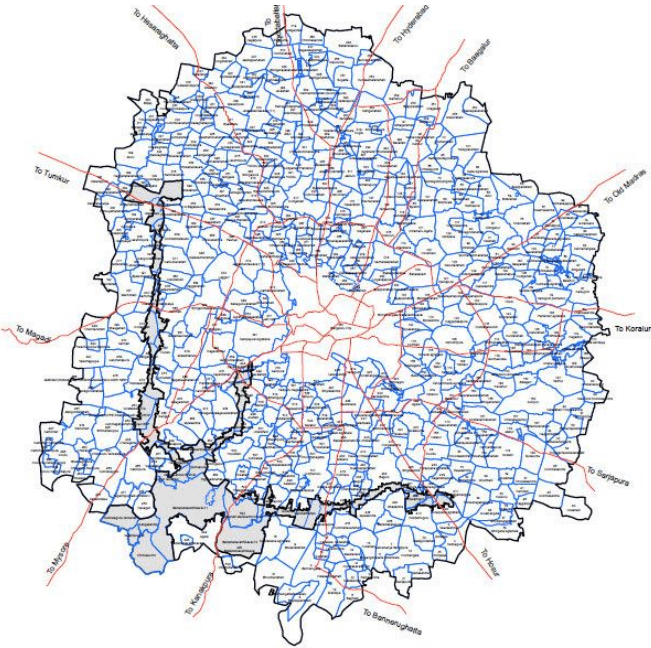
The LPA of BDA covers 537 revenue villages (fully or in parts) and area under city survey sheets (1 to 97) admeasuring 1206.97 Sqkm. It is important to note that several villages are partly with LPA of BDA and Partly with LPA of BMICAPA. Figure 3-2 presents the map showing villages falling partly and fully within BMICAPA.
Figure 3-2: Villages falling Partly & Fully within LPA of BMICAPA
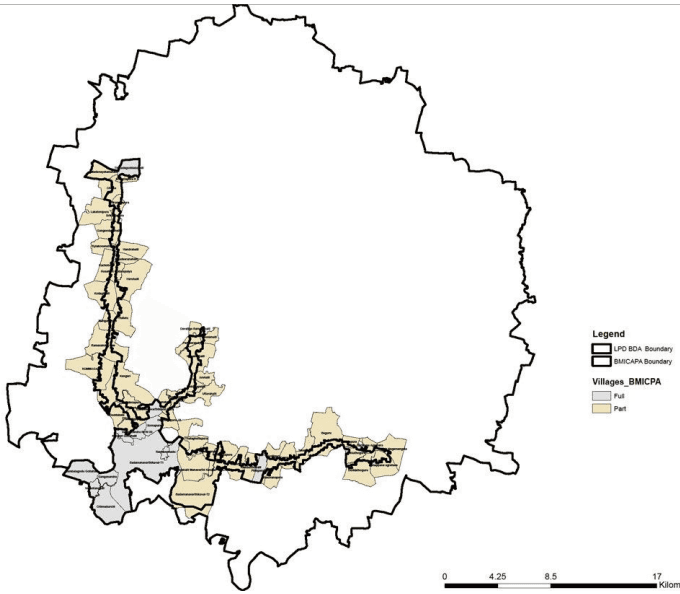
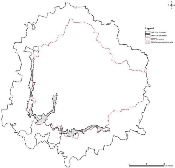
Figure 3-3 presents the overlay of extent of BBMP and extent of LPA of BDA highlighting the extents falling within BMICAPA.
BANGALOE AUTHORITY ★
Figure 3-3: Extent of BBMP within LPA of BDA and LPA of BMICAPA
The list of villages and description of running boundary for LPA of BDA for RMP-2031 is enclosed as Annexure – 1.