4.1 General
The preparation of Revised Master Plan for the LPA of Bengaluru required reliable and factual data regarding existing physical and socio-economic conditions such as existing land use, housing, transport, industries, employment and social services such as educational, health and recreational facilities, etc for analysing the existing situation and make projections for the future requirements. RMP-2031 made rigorous efforts for the collection of data from various sources including secondary source as well as primary surveys and studies with a clearly defined objective of minimising the variations/ discrepancies.
4.2 Data from Secondary Sources
The secondary information available with BDA as well as various agencies of the state and the central government has been collected for the preparation of RMP-2031.
1. Data with BDA:
The Planning Authority is a custodian of data base related to approved Layouts and Development Plans for Residential and Non-Residential developments and Change of Land Use (CLU) cases. As part of master plan preparation process, all these Development Plans, Layouts and CLU cases approved after the final notification of RMP 2015 have been assimilated, translated and integrated in GIS database for incorporation in the proposals.
2. Data from Government Departments (State and Central):
Large amount of data/ information has been collected from various government departments and same has been collated, complied, selected, assimilated, analysed and mapped for the preparation of RMP-2031. The following key areas have been incorporated as part of the GIS database created for RMP 2031 based on the data provided by various government departments/ agencies:
i Revenue maps procured from Department of Survey Settlement and Land Records, GoK
ii Mapping of Public Transport Infrastructure (Namma Metro, BMTC, and KSRTC) and Logistics facilities like Truck Terminals, ICD.
iii Detailed inventory of slums within BMA (notified & non-notified) and spatial Mapping of slums
iv Detailed inventory and mapping of Lakes within BMA
v Mapping of Forest Areas, Eco-Sensitive Areas and Protection Areas
vi Mapping of spread of health and education facilities within BMA
vii Mapping of Air Funnel Zones
viii Mapping of SWM Infrastructure and Facilities within BMA
BANGALOE AUTHORITY ★
4.3 Primary Surveys
The primary surveys conducted as part of preparation of RMP-2031 includes DGPS Surveys, Existing Land Use Survey, Socio-economic Survey, Traffic and Transportation Surveys, Market Tracking and Housing Supply Survey, Heritage Survey, Lake Mapping, etc aimed at preparation of base map with various layers depicting physical, natural and administrative features; existing land use survey maps and creation of analytical base for arriving at proposals supplementing the inputs from the public consultation process.
1. DGPS Surveys for Preparation of Base Map:
DGPS surveys were conducted over 1200 points across BMA to help identify survey parcels points/corners for integration of revenue maps procured from Department of Survey Settlement and Land Records, GoK in the GIS based Base Map prepared using high resolution stereo pair satellite imagery procured from National Remote Sensing Agency.
2. Existing Land Use Survey:
Extensive field surveys were carried out to map the existing land use and cross verification of the features extracted from satellite imagery using the base map. The ELU Survey was conducted in line with the provisions of Karnataka Planning Authority Rules, 1967 (as amended from time to time) during Nov 01, 2014 to Nov 30, 2015. The details of Existing Land Use Map 2015 for RMP 2031 are given in Chapter 5 of this report.
3. Traffic and Transportation Surveys:
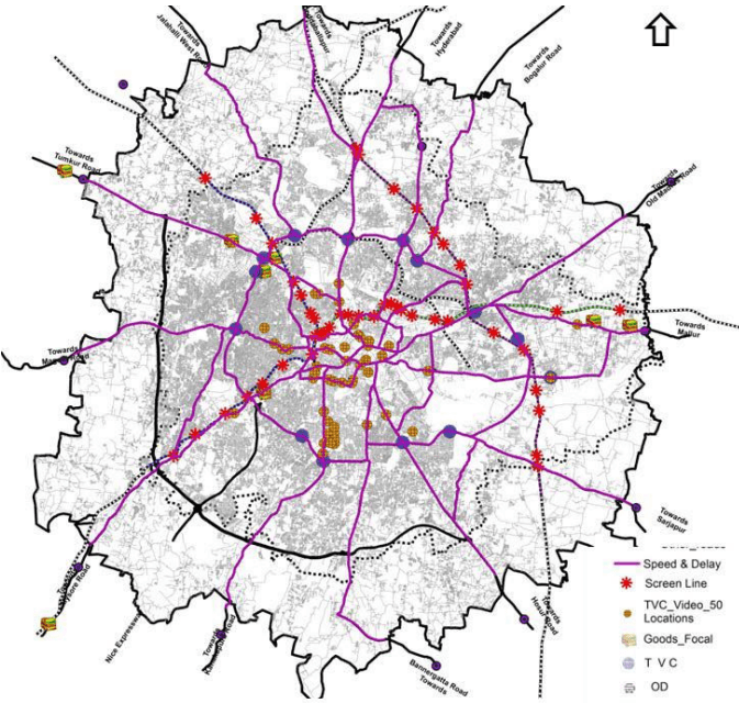
Traffic & Transportation surveys were conducted to assess the traffic and transport characteristic of the study area (base line scenario) and provide inputs to developing the transport model. Focus of the surveys has been on obtaining traffic volume data on as many roads as possible. This has been done as for using a process called ‘Most likely Trip estimates from traffic volume counts’ to correct and update Origin Destination Matrices syntheses from earlier studies like CTTP and CTTS. Following primary surveys were carried out across BMA during December 2014 to April 2015 and there locations are presented in Figure 4-1.
Screen Lines/ Classified Volume counts- 45 Locations (Video Surveys for 16 Hours)
OD surveys- 13 Location (24hrs for one day at 13 Outer Cordon Points)
Speed and Delay surveys – 375 km (using Floating Car Method)
Road Network inventory – 375 km (Major arterial roads)
Turning volume counts- 14 Locations (24 hrs for one day)
Goods Focal /ICD/ CFS/ Transport Nagar Survey- 8 Locations (24 hrs for One day)
Video Footage from Bengaluru City Traffic Police for 50 locations (one hr) was also used to capture volume counts at city centre.
AUTHORITY ★
Figure 4-1: Locations of Traffic and Transportation Surveys
4.4 Studies Conducted
In addition to secondary data collection and various primary surveys, the following studies have also been undertaken as part of the preparation of RMP 2031.
1. Review of RMP 2015 and BMR RSP-2031:
The review of the RMP-2015 has been carried out to derive the lessons learnt with respect to its implementation on ground and understand the emerging imperatives as a result of the envisioned provisions of RMP-2015. The BMR RSP-2031 has been reviewed with a perspective of integrating the broad spatio-policy framework for the region and aligning RMP-2031 with these provisions. The review has been discussed in Volume 1: Vision Document of Draft Revised Master Plan 2031.
2. Classification of Natural Drainage:
The Hon’ble NGT passed the judgement as part of the hearing of the PIL and issued guidelines for buffers applicable to lakes and different types of drains within the BMA during the course of preparation of the RMP-2031. The guidelines issued by the Hon’ble NGT necessitated the need for classification of natural drainage system within BMA. In this regard, a study for classification of natural drainage system based on contours and digital elevation model generated using high resolution stereo pair satellite imagery assessment and delineation natural drainage system was taken up for classification of streams into primary, secondary and tertiary. The classification has been carried using GIS software and in consultation with Karnataka State Natural Disaster Monitoring Centre. The RMP-2031 has earmarked the buffers based on the classification of the streams in the PLU Maps.
3. Urban Transport Model:
The traffic and transportation survey results and previous studies have been used to build a sophisticated urban transport model to replicate the “Bangalore Metropolitan Area” transportation system (roads, Congestion delays, transit system, etc.) with state-of-the-art software and modelling technology. The purpose of the model development is to develop a tool to help in understanding transport characteristics in the Future under changed Land use and Network conditions. A conventional 4 stage model with a combined mode choice cum distribution function has been calibrated. This model has been used to analyse the potential major future network enhancements such as introduction of an MRTS and allocating proposed land use. A very fine zoning system has been adopted (534 zones), covering Bengaluru Metropolitan Region (not only BMA). The Network was developed using the large GIS database that has been created for the RMP and hence boasts of more than 30000 links. Also all BMTC bus routes (~2500) are coded onto this Network. The Model has been developed using CUBE Voyager. The modes modelled are Car+ Taxi, Two Wheeler, Auto rickshaw, Public Transport and modes preloaded are MAV/Trucks/LCV. The Traffic Assignment is
BANGALOE AUTHORITY ★